Aerium Analytics
AI for road surface scanning
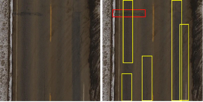
 (Left) An aerial image of a road containing different deformations to the
pavement. (Right) The aerial image of the road with red bounding boxes
designating the defects perpendicular to the road and yellow bounding boxes
designating the defects parallel with the road. Such distinction is not a
requirement of the project but could be of interest for judging severity.
(Left) An aerial image of a road containing different deformations to the
pavement. (Right) The aerial image of the road with red bounding boxes
designating the defects perpendicular to the road and yellow bounding boxes
designating the defects parallel with the road. Such distinction is not a
requirement of the project but could be of interest for judging severity.Introduction
Roads are a vital component of today’s society. They not only connect us to different cities, towns, provinces, and countries, but they also provide of a means of transporting goods and services. Typically, roads are constructed using materials such as concrete, or asphalt. Between the cold winter temperatures and hot summer temperatures as well as settling earth, cracks and potholes are bound to occur on roads. These result in further wear and tear on roads but also vehicles which transport goods and services as well as us to different parts of the world.
Alberta alone spent over 1.6 billion dollars in transportation related needs in 2020-21 1. Over 26% of this money went towards road construction and maintenance related expenditures. Roads undergo regular inspection; a detailed Surface Condition Rating occurs every two years in Alberta 2. This helps determine the priority in which maintenance should occur on roads in the province. One method of conducting these inspections could be done via aerial imagery. While an individual could go through these images to inspect the roads for cracks and potholes, is there a way that machine learning and computer vision could not only detect cracks but also classify their severity?
Problem Statement
Several techniques for road surveillance exist, from manual detection to machine detection methods. The use of an individual to inspect pavement takes a significant amount of work hours 3. The use of various machines such as microwave, ultrasound, etc. still require some form of analysis once the data has been collected. The analysis of such large data sets can also be time consuming for a single or even group of individuals and result in human error or even bias.
Using machine learning and computer vision to analyze this data enables a smaller likelihood of bias and error. While various types of data could be used to solve this problem, aerial RGB imagery can be collected quickly with minimal additional costs as well as decreased interruptions to standard operations. The use of RGB images will also allow for the interpretation of the severity of the deformations in the pavement.
For this project, the team will be given access to aerial RGB images of pavements with various defects including cracks and potholes. The goal is to develop a method which can detect defects in the payment using machine learning and computer vision techniques. Producing a system to adequately relay the severity of a detected defect will also be a goal of the project. We plan to focus on unsupervised machine learning techniques for this problem, as data in industry is often limited. Methods for addressing this problem may involve edge detection and cluster analysis for detection purposes and for classification, geometry may be useful. The overall goal is to find a method which requires limited user input for detecting and classifying defects found in pavement.
References
Government of Alberta. “Annual Report Transportation 2020-2021.” 2021. URL https://open.alberta.ca/dataset/d24ecf3f-d15a-4e41-b090-9e1a4c85949a/resource/d46ff3e4- 9180-48f1-94dc-1eda8d9b5771/download/trans-annual-report-2020-2021.pdf ↩︎
Transportation Alberta. “Highway Maintenance Guidelines and Level of Service Manual.” 2000 ↩︎
Yang C, Chen J, Li Z, Huang Y. Structural Crack Detection and Recognition Based on Deep Learning. Applied Sciences. 2021; 11(6):2868. https://doi.org/10.3390/app11062868 ↩︎